Unveiling North Dakota’s Winter Geometry From Space


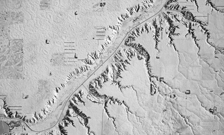
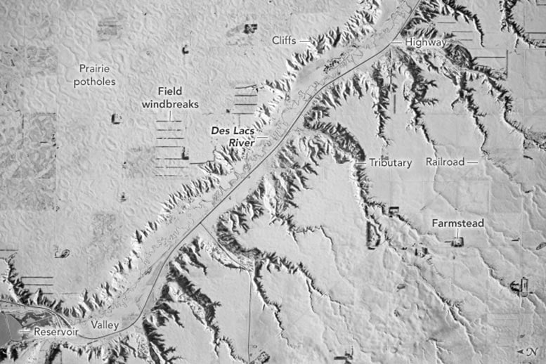
From space, an astronaut captures North Dakota’s winter landscape, showcasing the Des Lacs River, protective windbreaks, and fields organized in a grid. The region’s topography, marked by cliffs and tributaries, tells a story of ancient glaciers and erosive forces.
An astronaut aboard the International Space Station (ISS) took this detailed photo of snow-covered plains in northwestern North Dakota. The scene is crossed diagonally by a short 12-kilometer (7-mile) section of the Des Lacs River valley. A highway and the thin, contorted path of the Des Lacs River occupy the valley floor. Part of a reservoir, formed by a dam along this section of the river, is visible in the lower-left corner of the image. The straight line of a railroad crosses the view diagonally on the image’s right side.
Winter’s Cover and Summer’s Traces
Almost the entire landscape in this view is divided into rectangular fields. These are best seen along the left margin of the image. Summer images show that these rectangular features cover the entire field of view, although many were obscured by snow when this photo was taken in winter 2023.
Nature’s Barriers: Windbreaks in Agriculture
Breaking the pervasive snow blanket are dark-toned lines of trees that make up windbreaks. Windbreaks protect farm fields against winds that contribute to soil erosion and are aligned north-south because the dominant winds blow mainly from the west. Several small, dark patches in the view are also windbreaks. These are shorter, L- or U-shaped lines of trees surrounding farmsteads.
Geological Insights From the Des Lacs Valley
The Des Lacs valley is bordered by low cliffs about 60 meters (200 feet) high. The mid-morning sunlight illuminates cliffs on the northeast side of the valley while shadowing short tributaries on the southwest side. The hummocky surface in the top-left part of the image is dotted with numerous small ponds and wetlands, known as a prairie pothole landscape. This irregular surface is interpreted by scientists as the sediments deposited by glaciers that covered this part of North Dakota more than 10,000 years ago.
Erosive Forces at Work
The prominently shadowed tributaries occur only on the southwest slope of the Des Lacs valley, with no equivalents on the northeast side. The reason is that the slope on the southwest side is much steeper than the hummocky surface on the northeast side. Tributary streams flowing down the southwest slope therefore have greater erosive energy, allowing them to carve the small valleys of the tributaries.
Astronaut photograph ISS070-E-105381 was captured on December 11, 2023, with a Nikon D5 digital camera using a focal length of 1200 millimeters. It is provided by the ISS Crew Earth Observations Facility and the Earth Science and Remote Sensing Unit, Johnson Space Center. The image was taken by a member of the Expedition 70 crew. The image has been cropped and enhanced to improve contrast, and lens artifacts have been removed. The International Space Station Program supports the laboratory as part of the ISS National Lab to help astronauts take pictures of Earth that will be of the greatest value to scientists and the public, and to make those images freely available on the Internet. Caption by Justin Wilkinson, Texas State University, JETS II Contract at NASA-JSC.
Source link


