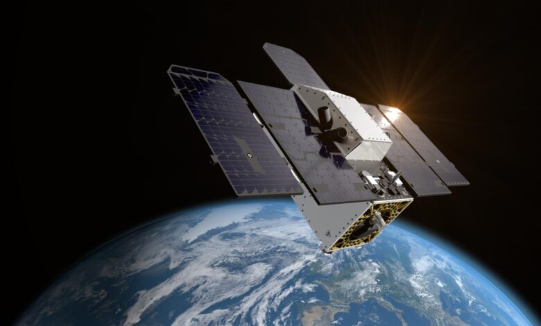
Tanager-1, a satellite equipped with advanced NASA technology, has been launched to monitor methane and carbon dioxide emissions globally.
Developed by the Carbon Mapper Coalition, this mission aims to detect and quantify emission sources with high accuracy, contributing significantly to climate change mitigation efforts. The satellite’s data will help identify super-emitters and facilitate data-driven environmental strategies.
Satellite Launch Success
Tanager-1, the Carbon Mapper Coalition’s first satellite, which carries a state-of-the-art, NASA-designed greenhouse-gas-tracking instrument, is in Earth orbit after lifting off aboard a SpaceX Falcon 9 rocket from Space Launch Complex 4E at Vandenberg Space Force Base in California at 11:56 a.m. PDT Friday, August 16. Ground controllers successfully established communications with Tanager-1 at 2:45 p.m. PDT the same day.
Advanced Imaging Technology
The satellite will use imaging spectrometer technology developed at NASA’s Jet Propulsion Laboratory in Southern California to measure methane and carbon dioxide point-source emissions, down to the level of individual facilities and equipment, on a global scale. Tanager-1 was developed as part of a philanthropically funded public-private coalition led by the nonprofit Carbon Mapper. Planet Labs PBC, which built Tanager-1, and JPL are both members of the Carbon Mapper Coalition and plan to launch a second Tanager satellite equipped with a JPL-built imaging spectrometer at a later date.
“The imaging spectrometer technology aboard Tanager-1 is the product of four decades of development at NASA JPL and truly in a class of its own,” said JPL Director Laurie Leshin. “The data that this public-private partnership provides on sources of greenhouse gas emissions will be precise and global, making it beneficial to everyone.”
Daily Operational Scope
Once in operation, the spacecraft will scan about 50,000 square miles (130,000 square kilometers) of Earth’s surface per day. Carbon Mapper scientists will analyze data from Tanager-1 to identify gas plumes with the unique spectral signatures of methane and carbon dioxide — and pinpoint their sources. Plume data will be publicly available online at the Carbon Mapper data portal.
Methane and carbon dioxide are the greenhouse gases that contribute most to climate change. About half of methane emissions worldwide result from human activities — primarily from the fossil fuel, agriculture, and waste management industries. Meanwhile, there is now 50% more carbon dioxide in the atmosphere than there was in 1750, an increase largely due to the extraction and burning of coal, oil, and gas.
“The Carbon Mapper Coalition is a prime example of how organizations from different sectors are uniting around a common goal of addressing climate change,” said Riley Duren, Carbon Mapper CEO. “By detecting, pinpointing, and quantifying super-emitters and making this data accessible to decision-makers, we can drive significant action around the world to cut emissions now.”
Spectral Detection Capabilities
The imaging spectrometer aboard the satellite measures hundreds of wavelengths of light that are reflected by Earth’s surface. Different compounds in the planet’s atmosphere — including methane and carbon dioxide — absorb different wavelengths of light, leaving spectral “fingerprints” that the imaging spectrometer can identify. These infrared fingerprints can enable researchers to pinpoint and quantify strong greenhouse gas emissions, potentially accelerating mitigation efforts.
Tanager-1 is part of a broader effort to make methane and carbon dioxide data accessible and actionable. That effort includes using measurements provided by NASA’s EMIT (Earth Surface Mineral Dust Source Investigation), an imaging spectrometer developed by JPL and installed on the International Space Station.
Carbon Mapper is a nonprofit organization dedicated to addressing climate change through advanced technology. It focuses on the precise detection, quantification, and mapping of methane and carbon dioxide emissions at a facility level. By utilizing high-resolution imaging spectrometers aboard satellites, such as the Tanager-1, Carbon Mapper aims to identify “super-emitters”—sources that disproportionately contribute to atmospheric pollution.
The organization operates within a collaborative framework, involving public and private partners, including NASA’s Jet Propulsion Laboratory, Planet Labs PBC, and several academic and philanthropic entities. This coalition harnesses satellite technology to provide data that is both accessible and actionable, facilitating timely and informed decision-making to mitigate the effects of climate change.
Carbon Mapper’s mission is not only to fill gaps in existing emissions monitoring systems but also to empower scientific research, policy-making, and environmental stewardship at global and local scales. Through its efforts, it contributes significantly to the emerging global ecosystem of environmental monitoring and climate action.
Source link