Nature’s Fury Unleashed in the Pacific: Hurricane Hone Wreaks Havoc


Late in the 2024 hurricane season, the Northeast Pacific Basin saw significant storm activity, including Hurricane Hone, which, despite not making direct landfall, caused substantial damage in Hawaii with high winds and floods.
Following Hone, Hurricanes Gilma and Hector also emerged but were forecast to weaken due to less favorable environmental conditions. This season contributed significantly to the basin’s cyclone energy, with Hone and Gilma accounting for the majority.
Season Overview and Hurricane Hone’s Path
The first few months of the 2024 hurricane season were quiet in the Northeast Pacific Basin, but storm activity picked up in late August.
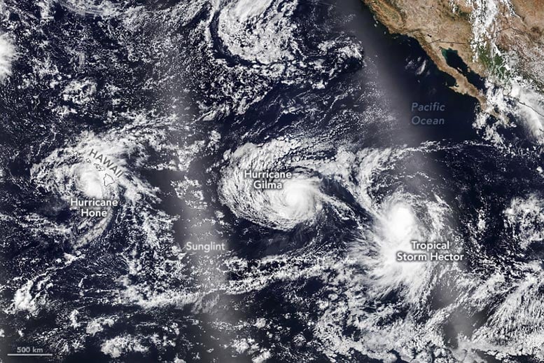
On August 20, a disturbance emerged southeast of Hawaii and strengthened steadily until five days later, when it passed 50 miles (80 kilometers) south of South Point on the Island of Hawai‘i as a Category 1 storm. When the VIIRS (Visible Infrared Imaging Radiometer Suite) on the NOAA-21 satellite captured this image on August 25, Hurricane Hone was moving west-northwest at 14 miles (23 kilometers) per hour and weakening.
Impact of Hurricane Hone on Hawaii
Though Hone did not strike the island chain directly, it still delivered damaging winds, soaking rains, and life-threatening surf. Some parts of Hawaii received more than 10 inches (25 centimeters) of rain within 24 hours and faced localized flash floods. Some 24,000 utility customers lost power initially, though the number dropped to 2,400 by the afternoon of August 26, according to PowerOutage.us.
Following Storms: Gilma and Hector
Trailing a few thousand kilometers behind Hone was Gilma, a disturbance that had grown to Category 3 strength when the image was acquired. Forecasters expect the storm to weaken in the coming days as it moves westward and northward and encounters an environment with higher wind shear, cooler water temperatures, and dry air.
Ever farther to the east was Hector, a tropical storm with maximum sustained winds of 45 miles (75 kilometers) per hour at the time of this image. Like Gilma, forecasters expect Hector to weaken in the coming days as it encounters unfavorable conditions, including Gilma’s cold water wake.
Seasonal Analysis and Tropical Storm Trends
As of August 26, the northeastern Pacific had seen nine named storms since the start of the hurricane season. Most were short-lived storms that fizzled soon after forming, so Hone and Gilma together accounted for roughly 60 percent of the basin’s total accumulated cyclone energy (ACE) through August 26, according to statistics compiled by Colorado State University researchers. ACE is an index that incorporates storm longevity, making it easier to compare individual storms and seasons. The total ACE on August 26, 2024, was 43.1 compared to the 1991–2020 climatological average of 72.8 for that date.
Though tropical storms often brush Hawaii, it is unusual for them to hit the islands directly. That’s because ocean temperatures around the island are often lower than in other parts of the Pacific; a subtropical high usually helps steer storms away; and high wind shear around the island tends to break storms up, according to The Weather Channel.
NASA Earth Observatory image by Michala Garrison, using VIIRS data from NASA EOSDIS LANCE, GIBS/Worldview, and the Joint Polar Satellite System (JPSS).
Source link


