NASA’s Mars Odyssey Captures Huge Volcano in Breathtaking New View

NASA’s 2001 Mars Odyssey orbiter captured this single image of Olympus Mons, the tallest volcano in the solar system, on March 11, 2024. Besides providing an unprecedented view of the volcano, the image helps scientists study different layers of material in the atmosphere, including clouds and dust. Credit: NASA/JPL-Caltech/ASU
The 23-year-old orbiter is taking images that offer horizon-wide views of the Red Planet similar to what astronauts aboard the International Space Station see over Earth.
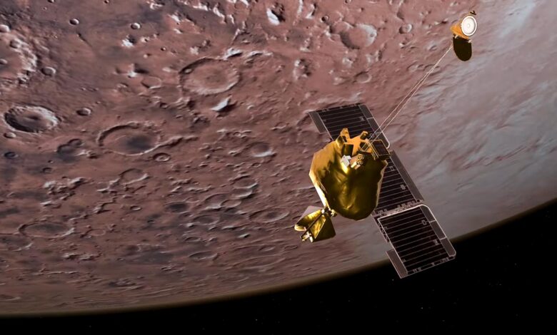
NASA’s 2001 Mars Odyssey orbiter celebrates 100,000 orbits around Mars, providing valuable data and stunning images like the recent horizon shot of Olympus Mons. The mission, managed by NASA’s Jet Propulsion Laboratory, uses innovative techniques for capturing unique perspectives of the Martian surface and atmosphere, aiding in scientific understanding and future explorations.
Celebrating a Milestone: 100,000 Martian Orbits
NASA’s longest-lived Mars robot recently marked a new milestone. On June 30 it completed 100,000 trips around the Red Planet since launching 23 years ago. During that time, the 2001 Mars Odyssey orbiter has been mapping minerals and ice across the Martian surface, identifying landing sites for future missions, and relaying data to Earth from NASA’s rovers and landers.
Scientists recently used the orbiter’s camera to take a stunning new image of Olympus Mons, the tallest volcano in the solar system. The image is part of a continuing effort by the Odyssey team to provide high-altitude views of the planet’s horizon. (The first of these views was published in late 2023.) Similar to the perspective of Earth astronauts get aboard the International Space Station (ISS), the view enables scientists to learn more about clouds and airborne dust at Mars.
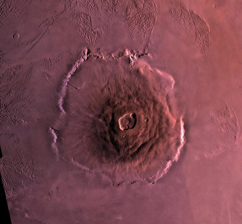
Shown here is a digital mosaic of Olympus Mons, the largest known volcano in the Solar System, taken by the Viking 1 Orbiter. It is 27 kilometers high, over 600 kilometers at the base, and is surrounded by a well-defined scarp that is up to 6 km high. Lava flows drape over the scarp in places. Much of the plains surrounding the volcano are covered by the ridged and grooved ‘aureole’ of Olympus Mons. The origin of the aureole is controversial, but may be related to gravity sliding off of the flanks of an ancestral volcano. The summit caldera (central depression) is almost 3 km deep and 25 km across. It probably formed from recurrent collapse following drainage of magma resulting from flank eruptions. Credit: NASA/JPL-Caltech/USGS
Taken on March 11, the most recent horizon image captures Olympus Mons in all its glory. With a base that sprawls across 373 miles (600 kilometers), the shield volcano rises to a height of 17 miles (27 kilometers).
“Normally we see Olympus Mons in narrow strips from above, but by turning the spacecraft toward the horizon we can see in a single image how large it looms over the landscape,” said Odyssey’s project scientist, Jeffrey Plaut of NASA’s Jet Propulsion Laboratory (JPL) in Southern California, which manages the mission. “Not only is the image spectacular, it also provides us with unique science data.”
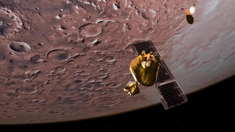
NASA’s Mars Odyssey orbiter arrived at Mars in 2001 to detect water and shallow buried ice on Mars and to study the planet’s radiation environment. Odyssey is part of the Mars Exploration Program’s long-term effort of robotic exploration of the red planet. Credit: NASA/JPL-Caltech
In addition to offering a freeze frame of clouds and dust, such images, when taken across many seasons, can give scientists a more detailed understanding of the Martian atmosphere.
A bluish-white band at the bottom of the atmosphere hints at how much dust was present at this location during early fall, a period when dust storms typically start kicking up. The purplish layer above that was likely due to a mixture of the planet’s red dust with some bluish water-ice clouds. Finally, toward the top of the image, a blue-green layer can be seen where water-ice clouds reach up about 31 miles (50 kilometers) into the sky.
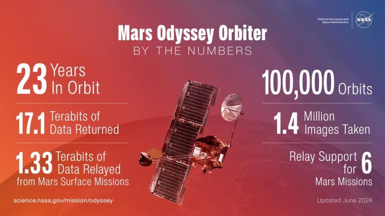
This infographic highlights just how much data and how many images NASA’s 2001 Mars Odyssey orbiter has collected in its 23 years of operation around the Red Planet. Credit: NASA/JPL-Caltech
How They Took the Picture
Named after Arthur C. Clarke’s classic science-fiction novel “2001: A Space Odyssey,” the orbiter captured the scene with a heat-sensitive camera called the Thermal Emission Imaging System, or THEMIS, which Arizona State University in Tempe built and operates. But because the camera is meant to look down at the surface, getting a horizon shot takes extra planning.
By firing thrusters located around the spacecraft, Odyssey can point THEMIS at different parts of the surface or even slowly roll over to view Mars’ tiny moons, Phobos and Deimos.
The recent horizon imaging was conceived as an experiment many years ago during the landings of NASA’s Phoenix mission in 2008 and Curiosity rover in 2012. As with other Mars landings before and after those missions touched down, Odyssey played an important role relaying data as the spacecraft barreled toward the surface.
Laura Kerber, deputy project scientist for NASA’s Mars Odyssey orbiter, explains how and why the spacecraft in May 2023 captured a view of the Red Planet similar to the International Space Station’s view of Earth. Credit: NASA/JPL-Caltech
To relay their vital engineering data to Earth, Odyssey’s antenna had to be aimed toward the newly arriving spacecraft and their landing ellipses. (See image below.) Scientists were intrigued when they noticed that positioning Odyssey’s antenna for the task meant that THEMIS would be pointed at the planet’s horizon.
“We just decided to turn the camera on and see how it looked,” said Odyssey’s mission operations spacecraft engineer, Steve Sanders of Lockheed Martin Space in Denver. Lockheed Martin built Odyssey and helps conduct day-to-day operations alongside the mission leads at JPL. “Based on those experiments, we designed a sequence that keeps THEMIS’ field-of-view centered on the horizon as we go around the planet.”
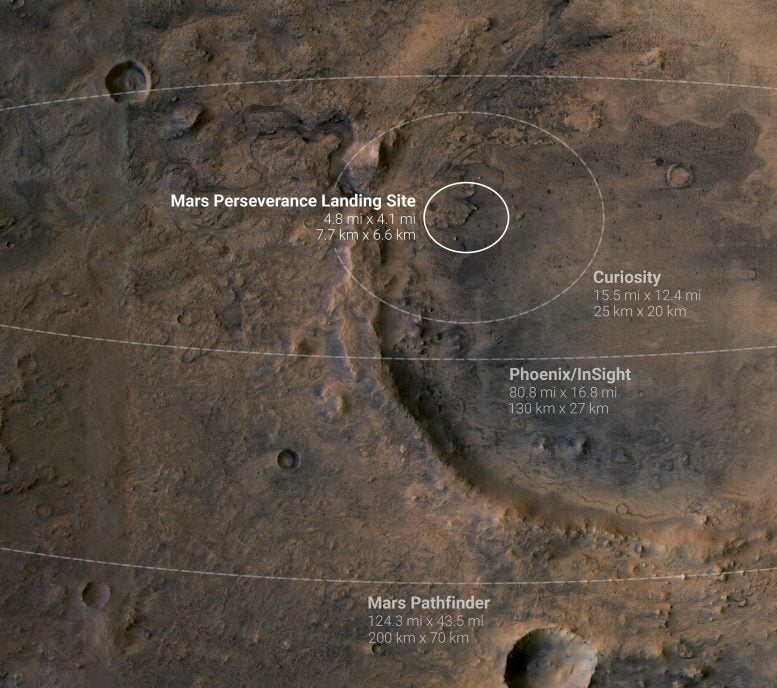
This annotated image shows landing ellipses for five NASA missions to Mars. A landing ellipse is the region within which a probe is expected to land based on its trajectory as it approaches the planet. A smaller landing ellipse means engineers have created a more precise model of the probe’s expected trajectory. The four ellipses shown here are for the Perseverance Mars rover, Curiosity Mars rover, InSight Mars lander, Phoenix lander, and Mars Pathfinder probe. Credit: NASA/JPL-Caltech
The Secret to a Long Space Odyssey
What’s Odyssey secret to being the longest continually active mission in orbit around a planet other than Earth?
“Physics does a lot of the hard work for us,” Sanders said. “But it’s the subtleties we have to manage again and again.”
These variables include fuel, solar power, and temperature. To ensure Odyssey uses its fuel (hydrazine gas) sparingly, engineers have to calculate how much is left since the spacecraft doesn’t have a fuel gauge. Odyssey relies on solar power to operate its instruments and electronics. This power varies when the spacecraft disappears behind Mars for about 15 minutes per orbit. And temperatures need to stay balanced for all of Odyssey’s instruments to work properly.
“It takes careful monitoring to keep a mission going this long while maintaining a historical timeline of scientific planning and execution — and innovative engineering practices,” said Odyssey’s project manager, Joseph Hunt of JPL. “We’re looking forward to collecting more great science in the years ahead.”


