Microplastic “Hotspots” Identified in Long Island


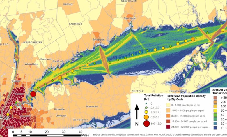
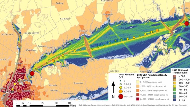
Concentration of all types of microplastic and anthropogenic microfiber pollution found in this study overlaid on a heat map showing the concentration of shipping traffic (all types) and a heatmap showing population density. In all cases, red indicates higher numbers. Credit: Staffordshire University
Forensic and environmental specialists have collaborated to create a new scientific technique for identifying microplastic pollution ‘hotspots’ in open waters.
The technique was tested in New York’s Long Island Sound through a collaboration involving Staffordshire University, The Rozalia Project for a Clean Ocean, and Central Wyoming College.
Professor Claire Gwinnett from Staffordshire University explained: “Long Island Sound was a location of interest because it has lots of factors that can cause pollution. It is an estuary that has high populations of wildlife, it is a busy transport route frequented by cargo ships, and is a popular fishing area. Located adjacent to New York City, it is also highly populated and a major tourist destination.”
Identifying Pollution Hotspots
Funded, in part, by the National Geographic Society, the study saw samples collected from the deck of the 60′ oceanographic sailing research vessel, American Promise. The team took 1 litre ‘grab samples’ of surface water every 3 miles from the East River along the middle of Long Island Sound to The Race, where it meets Rhode Island Sound.
Grab sampling allows analysis of specific locations, with the researchers applying a statistical approach to identify hotspots where microplastics were most in evidence.
“People often use the term ‘hotspot’ but it is not scientifically defined. Previous studies have used largely subjective methods, without the use of any rules or thresholds that differentiate hotspots from non-hotspots,” Professor Gwinnett commented. “Our study proposed a simple yet objective method for determining hotspots using standard deviation values. This is the first time that this has been done.”
Two primary and two secondary hotspots were observed, near either end of the sampling area. There is potentially a “bottleneck” effect in the narrower zones or, conversely, a dilution effect in the wider section of Long Island Sound. Similarly, hotspots were observed as being close to or in line with a river mouth, specifically the Thames and Connecticut Rivers.
Overlaying heat maps of various types of shipping and vessel traffic with the microparticle heat map from this study show potential similarities. In particular, between areas of high recreational and passenger vessel traffic and higher microplastic concentration.
Implications and Further Research
Professor Gwinnett said: “We need to consider factors that might influence these results, such as population, geography, and human use. The identified hotspots, however, were found in both densely populated areas and adjacent to some of the least densely populated land areas surrounding Long Island Sound.
“The first step in combatting this type of pollution is by characterizing microparticle samples so that we can begin to understand where they might have come from.”
97% of samples contained man-made particulates. Microparticles were classified as 76.14% fibers and 23.86% fragments. 47.76% of the fibers were synthetic and 52.24% were non-synthetic.
Forensic science approaches developed by Staffordshire University were used to analyze the microparticles – including type, color, shape, material, presence of delusterant, and width – which identified 30 unique categories of potential sources of pollution.
Rachael Miller, Expedition lead and Rozalia Project Founder, explained: “Unlike larger fragments of plastic, which may exhibit clear features that easily identify its original sources, such as bottle cap ridges or a partial logo, this is generally very difficult for microparticles unless an analysis approach which fully characterizes the particle is used.
“Identifying a specific type of item from which a microparticle came from e.g. pair of jeans, carpet, tire or personal hygiene product increases the likelihood of discovering the mechanism for transport to the environment. That, in turn, increases opportunities to prevent a subset of microplastic pollution.”
The authors are now calling for reference databases of potential pollutants of waterways. PhD researcher Amy Osbourne specializes in forensic fiber analysis at Staffordshire University after progressing from the undergraduate degree in Forensic Investigation.
She said: “We cannot confidently identify the sources of pollution without being able to cross reference samples against large, easily searched known provenance databases. Such databases are already used in forensic science when identifying sources of evidence found at crime scenes. For example, we might begin with a database of all the different types of fishing nets or tarpaulins that we know are commonly used in areas like Long Island Sound.”
Professor Gwinnett added: “While more research is needed to fully understand microplastics concentrations and implications of this pollution, the very presence is enough to engage in solution development and solution-deployment.”
Reference: “Microplastic and anthropogenic microfiber pollution in the surface waters of the East River and Long Island Sound, USA” by Rachael Z. Miller, Brooke Winslow, Kirsten Kapp, Amy Osborne and Claire Gwinnett, 27 December 2023, Regional Studies in Marine Science.
DOI: 10.1016/j.rsma.2023.103360


