Boreal forests in Canada’s Northwest Territories have evolved to burn, but the increasing frequency of fires is putting ecosystems to the test.
Canada’s northern boreal forests, reliant on periodic fires for renewal, are facing challenges from increased fire frequencies and climate extremes. Satellites play a vital role in tracking these fires, many of which burn unchecked due to their remote locations. The combination of drought and record temperatures has intensified these fires, threatening the resilience of these crucial ecosystems.
Fire-Dependent Ecosystems of Northern Canada
The boreal forests of northern Canada have evolved to burn. These forests are dominated by black spruce, a type of evergreen that is not just tolerant of fire but dependent on it.
Black spruce has waxy, resinous needles adapted to ignite during lightning storms and burn vigorously. The forests thrive if they burn every century or so because fires open the canopy up to light, stimulate new growth, and help maintain biodiversity. Fires also melt away the waxy coating on cones of black spruces allowing them to deposit seeds uniquely designed to thrive in charred, acidic soils. But Canada’s black spruce boreal forests have been burning more frequently in recent decades, putting even these fire-loving forests under strain.
Wildfire Monitoring via Satellite
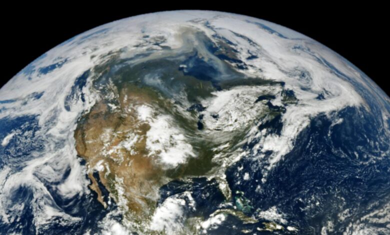
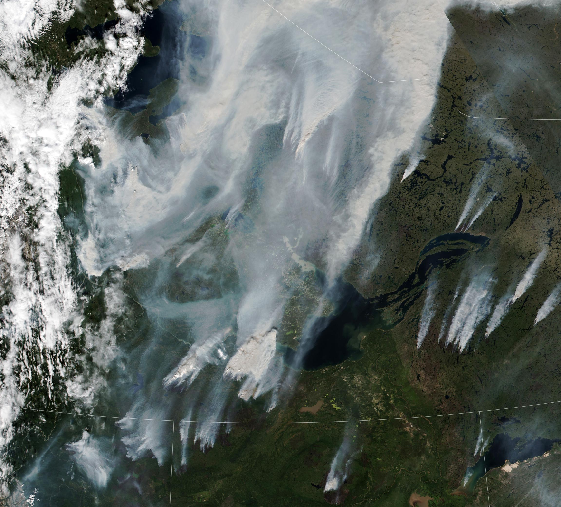
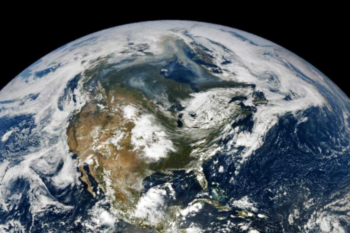
When the VIIRS (Visible Infrared Imaging Radiometer Suite) on the NOAA-20 satellite captured this image of smoke streaming throughout the region on August 11, 2024, the sensor detected nearly 100 active fires burning in the Northwest Territories, according to data posted by the territory’s government. The Canadian government, including the Northwest Territories, uses hotspot data from the Fire Information for Resource Management System (FIRMS), a fire monitoring system developed by NASA, to help detect and track wildfires. The image below, captured by NASA’s EPIC (Earth Polychromatic Imaging Camera) on NOAA’s DSCOVR satellite, shows a river of smoke from the fires in western Canada winding its way over the Hudson Bay.
Most fires in the Northwest Territories burn far from towns or infrastructure, so authorities let many of them burn themselves out, a process that can take weeks or even months depending on the weather. Of the 96 fires active on August 11, Canadian authorities reported that 88 of them burned unhindered by firefighting efforts. Firefighters had controlled five fires and were in the process of suppressing one, according to the territory’s government. None of the fires were close enough to settlements to trigger evacuation orders. However, dense smoke has triggered air quality warnings for fifteen Northwest Territories communities, including settlements in the North Slave, South Slave, Dehcho, and Sahtu regions.
Climate Challenges and Fire Response
The fires coincided with a drought classified as moderate to extreme by the North American Drought Monitor and a week of extreme warmth that broke temperature records in several places in the Northwest Territories, including the towns of Aklavik, Inuvik, Fort McPherson, and Tuktoyaktuk. All four communities surpassed 30 degrees Celsius (86 degrees Fahrenheit); Fort McPherson’s temperature soared to a remarkable 34.9°C (94.8°F) on August 7 and 8.
Though Canada’s black spruce forests are accustomed to fire, ecologists who study them are finding that some forests in the region are struggling to recover after fires due to the increasing frequency and size of fires in the region. One study led by Jennifer Baltzer, an ecologist at Wilfrid Laurier University, found that black spruce’s ability to regenerate declined at 38 percent of the 1,500 recently burned forest sites included in the study and failed to regenerate entirely at 18 percent of the sites—unusually high percentages compared to the historic norm. The analysis was based on tree regeneration data compiled and analyzed as part of NASA’s Arctic-Boreal Vulnerability Experiment (ABoVE).
A Record-Breaking Year Reviewed
Many of the areas burning in this image also burned in 2023, during Canada’s worst wildfire season on record. However, the total number of fires and the number of hectares burned in the Northwest Territories through mid-August 2024 are below the 10-year average so far, according to data released by Canadian authorities. The extent of burning in neighboring British Columbia and Alberta through mid-August 2024, however, was above average.
NASA Earth Observatory images by Lauren Dauphin, using VIIRS data from NASA EOSDIS LANCE, GIBS/Worldview, and the Joint Polar Satellite System (JPSS) and data from DSCOVR EPIC.
Source link