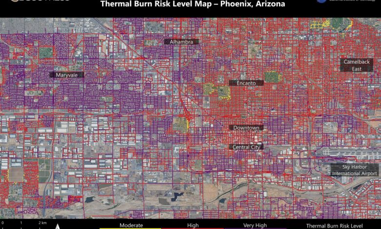

NASA’s ECOSTRESS instrument on June 19 recorded scorching roads and sidewalks across Phoenix where contact with skin could cause serious burns in minutes to seconds, as indicated in the legend above. Credit: NASA/JPL-Caltech
Roads and sidewalks in some areas get so hot that skin contact could result in second-degree burns.
NASA mapped Phoenix’s high surface temperatures using the ECOSTRESS instrument, revealing burn risks and the cooling benefits of green areas. This study underscores the urban heat challenges and supports strategic urban planning.
At NASA’s Jet Propulsion Laboratory (JPL) in Southern California, researchers mapped scorching pavement in Phoenix where contact with skin — from a fall, for example — can cause serious burns. The image shows land surface temperatures across a grid of roads and adjacent sidewalks, revealing how urban spaces can turn hazardous during hot weather.
Capturing Thermal Infrared Emissions
Data for this visualization of the Phoenix area — the fifth most populous city in the United States — was collected at 1:02 p.m. local time on June 19, 2024, by a NASA instrument aboard the International Space Station. Called ECOSTRESS (short for the Ecosystem Spaceborne Thermal Radiometer Experiment on Space Station), the instrument measures thermal infrared emissions from Earth’s surface.
The image shows how miles of asphalt and concrete surfaces (colored here in yellow, red, and purple, based on temperature) trap heat. The surfaces registered at least 120 degrees Fahrenheit (49 degrees Celsius) to the touch — hot enough to cause contact burns in minutes to seconds.

The ECOSTRESS radiometer has been deployed on the International Space Station (ISS) on the Japanese Experiment Module – External Facility (JEM-EF) site 10. At this location, the radiometer scan is perpendicular to the ISS velocity. Credit: NASA
Visualizing Heat in Urban Landscapes
The image also shows cooling effects of green spaces in communities like Encanto and Camelback East, in contrast to the hotter surface temperatures seen in Maryvale and Central City, where there are fewer parks and trees.
“We create these maps to be intuitive to users and help make data more accessible to the public and citizens scientists,” said Glynn Hulley, a JPL climate researcher. “We see them as a vital tool for planning effective heat interventions, such as tree planting, that can cool down the hottest roads and sidewalks.”
Homing in on Heat
At the lower right of the image is Phoenix’s Sky Harbor International Airport, where ECOSTRESS recorded some of the hottest land surface temperatures within the city —around 140 °F (60 °C). The air temperature on June 19 at the airport reached 106 °F (43 °C).
Air temperature, which is measured out of direct sunlight, can differ significantly from the temperature at the land surface. Streets are often the hottest surfaces of the built environment due to dark asphalt paving that absorbs more sunlight than lighter-colored surfaces; asphalt absorbs up to 95% of solar radiation. These types of surfaces can easily be 40 to 60 °F (22 to 33 °C) hotter than the air temperature on a very hot day.
The Dual Purpose of ECOSTRESS
Launched to the International Space Station in 2018, ECOSTRESS has as its primary mission the identification of plants’ thresholds for water use and water stress, giving insight into their ability to adapt to a warming climate. But the instrument is also useful for documenting other heat-related phenomena, like patterns of heat absorption and retention.
To produce the image of Phoenix, scientists used a machine learning algorithm that incorporates data from additional satellites: NASA/USGS Landsat and Sentinel-2. The combined measurements were used to “sharpen” the surface temperatures to a resolution of 100 feet (30 meters) by 100 feet (30 meters).
More About ECOSTRESS
ECOSTRESS, or the Ecosystem Spaceborne Thermal Radiometer Experiment on Space Station, is a NASA instrument mounted on the International Space Station. It measures the thermal infrared radiation emitted from the Earth’s surface to study plant water use and stress levels, urban heat phenomena, and other heat-related aspects. By providing high-resolution temperature maps, ECOSTRESS helps scientists understand how plants respond to heat and drought and assists in urban planning by identifying hot spots in cities. This information is crucial for managing water resources and mitigating the effects of urban heat islands.